
US Radar Upgrades with Garmin GPS Technology
US Radar has integrated Garmin GPS technology into its most popular ground-penetrating radar (GPR) systems, upgrading its GPS software module. The GPS software now incorporates a split-screen view to display real-time radar-mapped job site imagery with maps from other sources.
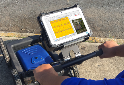 Public sources can include Google Earth or OpenStreetMap, or the system can use proprietary mapping sources, including site plans or as-built plans. US Radar’s split-screen capability provides an enhanced, real-time context for plotting and analyzing subsurface data. Operators can also combine radar and map data and export it into AutoCAD or ArcGIS software—while they’re on the job site.
“Field generation of radar-data maps in real time significantly increases the productivity and time-saving benefits of our GPR units,” said Matt Keys, US Radar system engineer.Keys said US Radar chose to integrate Garmin GPS technology with its systems because of Garmin’s superior performance in dense urban environments and areas with significant tree cover. On US Radar’s popular Quantum Imager and recently introduced Q5C models the Garmin GPS antenna is integrated within the US Radar antenna.
Click US Radar Inc. for more information.
PRO CONTRACTOR RENTALS MAGAZINE


Pro Contractor Rentals provides information of value to rental centers who focus time, resources and attention on meeting the demands of construction contractors and other equipment rental customers.